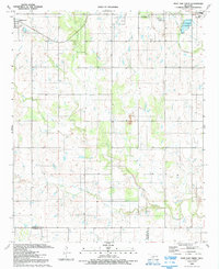
1991 Map of Post Oak Creek
USGS Topo · Published 1992About this map
Post Oak Creek and its southern tributary, Little Post Oak Creek, drain the agricultural plains of southwestern Oklahoma in this early 1990s survey. The landscape is defined by a grid of rural roads and scattered water resources, including Sandy Creek and the Sew Disp Ponds near Indiahoma. The northeastern corner reveals a significant concentration of cultural and community sites centered around the town of Cache. Here, researchers can identify the Comanche Tribal Cultural Center and the Cache Indian Ch of the Nazarene. This area also includes the Cache Indian Cem, providing a detailed record of the region's tribal heritage and community development. The topography is relatively level, broken by various Gravel Pits and the winding paths of West Cache Creek and Rock Creek, which intersect the northern boundary near a prominent Radio Tower.
Find a feature on this map
16 named features on this map. Tap any name to fly to it.
Don’t see what you’re looking for? This feature index may not catch every label — zoom into the map to look around manually.
Map Details
Editions of this 1991 Post Oak Creek Map
This is the sole edition of this map. No revisions or reprints were ever made.
Other maps of this area

1937 · Cache
USGS Topo · 1:48,000

1937 · Quanah Mountain
USGS Topo · 1:24,000

1942 · Cache
USGS Topo · 1:62,500

1949 · Mount Scott
USGS Topo · 1:24,000

1949 · Quanah Mountain
USGS Topo · 1:24,000

1950 · Snyder
USGS Topo · 1:62,500

1955 · Lawton
USGS Topo · 1:250,000

1956 · Post Oak Creek
USGS Topo · 1:24,000

1956 · Odetta
USGS Topo · 1:24,000
1956 · Quanah Mountain
USGS Topo · 1:24,000