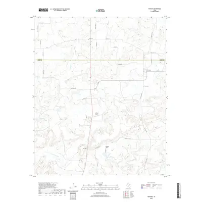
2019 Map of Postoak
USGS Topo · Published 2019About this map
Postoak and its surrounding countryside in Jack and Clay counties sit at a crossroads of small-town Texas history and drainage into the W Fork Trinity River. The landscape is marked by several family-named landmarks and historical burial grounds, including the Prospect Cem to the north and the Silver Hill Cem near the center of the sheet. Modern aviation is represented by the uniquely named Flyin Armadillo Airport, located just north of the Bear Mtn prominence. Drainage through the region is defined by the winding paths of Turkey Cr and Jones Cr, which feed into local basins such as Ellenburg Lake and Garner Lake. The settlement patterns along FM 2127 and Pudding Valley show a rural community built around small-scale water features and local ranch roads.
Find a feature on this map
37 named features on this map. Tap any name to fly to it.
Don’t see what you’re looking for? This feature index may not catch every label — zoom into the map to look around manually.
Map Details
Editions of this 2019 Postoak Map
This is the sole edition of this map. No revisions or reprints were ever made.
Other maps of this area

1954 · Wichita Falls
USGS Topo · 1:250,000

1958 · Wichita Falls
USGS Topo · 1:250,000

1962 · Antelope Creek NE
USGS Topo · 1:24,000
1963 · Vashti
USGS Topo · 1:24,000

1964 · Cundiff
USGS Topo · 1:24,000

1964 · Johnson Lake
USGS Topo · 1:24,000

1964 · Lynn Creek
USGS Topo · 1:24,000
1964 · Newport
USGS Topo · 1:24,000

1964 · Antelope
USGS Topo · 1:24,000

1964 · Scotland SE
USGS Topo · 1:24,000