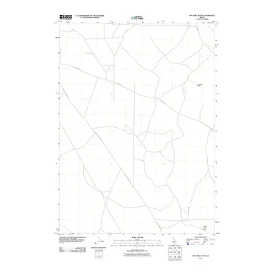
2011 Map of Pot Hole Butte
USGS Topo · Published 2011About this map
Pot Hole Butte and Winter Camp Butte stand as the primary topographical landmarks in this high-desert region of Owyhee County. The landscape is defined by its wide, open spaces and a network of essential roads that connect these distinct volcanic features. Drainage for the area is provided by Pot Hole Creek in the northeast and Browns Creek to the west. The primary transportation corridors include Castleford Rd, which cuts across the central portion of the map, and Clover Three Creek Rd, indicating the area's role as a transit zone between regional ranching outposts. This 2011 survey by the U.S. Geological Survey details the sparse but vital infrastructure of the Idaho desert, from the winding Pothole Rd to the quiet seasonal waterways that shape the local geography.
Find a feature on this map
7 named features on this map. Tap any name to fly to it.
Don’t see what you’re looking for? This feature index may not catch every label — zoom into the map to look around manually.
Map Details
Editions of this 2011 Pot Hole Butte Map
This is the sole edition of this map. No revisions or reprints were ever made.
Other maps of this area

1947 · Hot Spring
USGS Topo · 1:24,000

1948 · Indian Cove
USGS Topo · 1:62,500

1948 · Glenns Ferry
USGS Topo · 1:62,500

1948 · Pence Butte
USGS Topo · 1:24,000
1949 · Pot Hole Canyon
USGS Topo · 1:24,000
1949 · Pence Butte
USGS Topo · 1:24,000
1949 · Hot Spring
USGS Topo · 1:24,000
1951 · Glenns Ferry
USGS Topo · 1:62,500

1955 · Twin Falls
USGS Topo · 1:250,000

1956 · Blue Butte
USGS Topo · 1:62,500