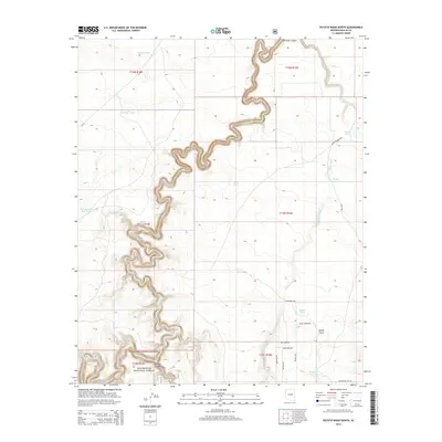
2014 Map of Potato Wash North
USGS Topo · Published 2014About this map
Chevelon Canyon carves a deep, serpentine path through the high plateau of Navajo County, defining the drainage patterns of this portion of the Sitgreaves National Forest. The landscape is dominated by the winding course of Chevelon Cr and the broad reach of Potato Wash, which converges with smaller draws like Sandy Draw. Human presence is evidenced primarily by a network of ranching roads and water management features essential for the arid environment. A cluster of cattle tanks, including Antelope Tank, Twentyeight Mile Tank, and the Rock on Dam Tank, are distributed across the township grids. Named roads such as Willie Wonka Rd and Antelope Dr provide access to remote areas like Durant and the elevated terrain of Whisper Ridge Run, while Wildcat Canyon marks the southern reach of the forest lands.
Find a feature on this map
32 named features on this map. Tap any name to fly to it.
Don’t see what you’re looking for? This feature index may not catch every label — zoom into the map to look around manually.
Map Details
Editions of this 2014 Potato Wash North Map
This is the sole edition of this map. No revisions or reprints were ever made.
Other maps of this area

1886 · Holbrook
USGS Topo · 1:250,000

1893 · Holbrook
USGS Topo · 1:250,000

1954 · Holbrook
USGS Topo · 1:250,000

1955 · Sunset Knoll 2 SE
USGS Topo · 1:24,000

1955 · Sunset Pass
USGS Topo · 1:62,500

1957 · Holbrook
USGS Topo · 1:250,000

1958 · Holbrook
USGS Topo · 1:250,000

1960 · Holbrook
USGS Topo · 1:250,000

1965 · Chevelon Crossing
USGS Topo · 1:24,000

1970 · Red Knoll
USGS Topo · 1:24,000