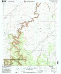
1998 Map of Potato Wash North
USGS Topo · Published 2000About this map
Sitgreaves National Forest dominates this high-desert landscape in northern Arizona, where the deep incisions of Chevelon Canyon and Wildcat Canyon converge. The terrain is defined by a sparse but critical network of water management features, including numerous livestock tanks such as Twenty-eight Mile Tank and Rock-on-Dam Tank, which support ranching in an arid environment. Evidence of local land use is visible through landmarks like the Mitchell Windmill and several corrals scattered near the rim of the canyon. The seasonal flow of Potato Wash and Sandy Drain illustrates the drainage patterns toward Chevelon Creek. This survey reflects the late 20th-century character of the region, emphasizing the remote nature of the Points of Wildcat and the essential infrastructure required for survival and industry on the Mogollon Rim's northern slopes.
Find a feature on this map
21 named features on this map. Tap any name to fly to it.
Don’t see what you’re looking for? This feature index may not catch every label — zoom into the map to look around manually.
Map Details
Editions of this 1998 Potato Wash North Map
This is the sole edition of this map. No revisions or reprints were ever made.
Other maps of this area

1886 · Holbrook
USGS Topo · 1:250,000

1893 · Holbrook
USGS Topo · 1:250,000

1954 · Holbrook
USGS Topo · 1:250,000

1955 · Sunset Knoll 2 SE
USGS Topo · 1:24,000

1955 · Sunset Pass
USGS Topo · 1:62,500

1957 · Holbrook
USGS Topo · 1:250,000

1958 · Holbrook
USGS Topo · 1:250,000

1960 · Holbrook
USGS Topo · 1:250,000

1965 · Chevelon Crossing
USGS Topo · 1:24,000

1970 · Red Knoll
USGS Topo · 1:24,000