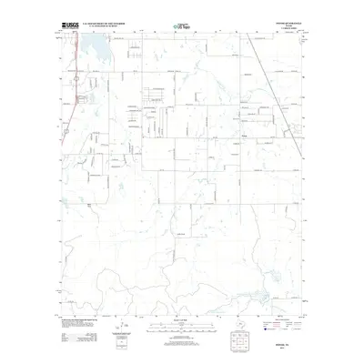
2012 Map of Potosi
USGS Topo · Published 2012About this map
Potosi sits at the center of this Taylor County landscape, showing the community's transition into a residential corridor south of Abilene in the early twenty-first century. The map documents the established local infrastructure of the Potosi School and Potosi Cem, while surrounding subdivisions like Allen Acres expand into the neighboring ranch land. The terrain is defined by the drainage of Lytle Cr and Spring Cr, flowing through a grid of rural roads and newer developments.
Find a feature on this map
102 named features on this map. Tap any name to fly to it.
Don’t see what you’re looking for? This feature index may not catch every label — zoom into the map to look around manually.
Map Details
Editions of this 2012 Potosi Map
This is the sole edition of this map. No revisions or reprints were ever made.
Other maps of this area

1890 · Abilene
USGS Topo · 1:125,000

1892 · Abilene
USGS Topo · 1:125,000

1954 · Abilene
USGS Topo · 1:250,000

1957 · Kirby Lake
USGS Topo · 1:62,500

1957 · Abilene West
USGS Topo · 1:24,000

1957 · Abilene East
USGS Topo · 1:24,000

1957 · Buffalo Gap
USGS Topo · 1:62,500

1958 · Abilene
USGS Topo · 1:250,000

1967 · Tuscola
USGS Topo · 1:24,000
1967 · Lawn
USGS Topo · 1:24,000