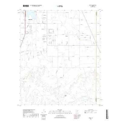
2019 Map of Potosi
USGS Topo · Published 2019About this map
Potosi and the surrounding ranchlands south of Abilene are defined by the transition from open plains to the prominent topographic rise of the Callahan Divide. This 2019 survey documents a landscape where residential expansion from the city meets traditional West Texas terrain. In the northern reaches, Kirby Lake and Cedar Creek provide critical water infrastructure, while the southeastern corner is marked by the rugged indentations of Bear Cove and Lytle Cove. Local history is anchored at the Potosi Cemetery, located near the intersection of several county roads that serve as the area's primary transportation network. The southern portion of the map shows the headwaters of the South Prong Pecan Bayou, illustrating the complex drainage patterns that flow away from the divide. The presence of the Soil Conservation Service Site 4a Reservoir further highlights the area's focus on water management and land conservation in this semi-arid region.
Find a feature on this map
97 named features on this map. Tap any name to fly to it.
Don’t see what you’re looking for? This feature index may not catch every label — zoom into the map to look around manually.
Map Details
Editions of this 2019 Potosi Map
This is the sole edition of this map. No revisions or reprints were ever made.
Other maps of this area

1890 · Abilene
USGS Topo · 1:125,000

1892 · Abilene
USGS Topo · 1:125,000

1954 · Abilene
USGS Topo · 1:250,000

1957 · Kirby Lake
USGS Topo · 1:62,500

1957 · Abilene West
USGS Topo · 1:24,000

1957 · Abilene East
USGS Topo · 1:24,000

1957 · Buffalo Gap
USGS Topo · 1:62,500

1958 · Abilene
USGS Topo · 1:250,000

1967 · Tuscola
USGS Topo · 1:24,000
1967 · Lawn
USGS Topo · 1:24,000