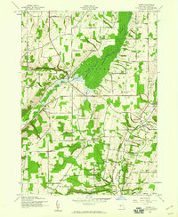
1942 Map of Potter
USGS Topo · Published 1960About this map
Potter Swamp dominates the central drainage of this Yates County landscape, where Flint Creek winds through a broad, low-lying basin. The settlement pattern in the early 1940s reveals a deeply established rural community structured around the townships of Potter, Italy, and Jerusalem. This survey captures the region just as wartime aerial photography began to refine topographic mapping, documenting the precise locations of numerous district schools and local burial grounds that anchored these upland valleys.
Find a feature on this map
29 named features on this map. Tap any name to fly to it.
Don’t see what you’re looking for? This feature index may not catch every label — zoom into the map to look around manually.
Map Details
Editions of this 1942 Potter Map
3 editions found

Other maps of this area

1900 · Naples
USGS Topo · 1:62,500

1900 · Canandaigua
USGS Topo · 1:62,500

1902 · Phelps
USGS Topo · 1:62,500

1903 · Naples
USGS Topo · 1:62,500

1903 · Canandaigua
USGS Topo · 1:62,500

1903 · Penn Yan
USGS Topo · 1:62,500

1913 · Naples
USGS Topo · 1:62,500

1942 · Prattsburg
USGS Topo · 1:31,680

1942 · Penn Yan
USGS Topo · 1:31,680

1942 · Pulteney
USGS Topo · 1:31,680