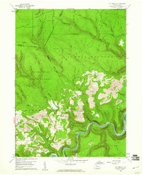
1959 Map of Pottersdale
USGS Topo · Published 1961About this map
The Susquehanna River West Branch snakes through a landscape defined by state forestry and heavy industry in this late 1950s survey. Much of the northern terrain is managed within Elk State Forest, while the south is dominated by Moshannon State Forest. Between these protected tracts, the central corridor shows the extensive footprint of surface mining, with numerous Strip Mines appearing near the settlement of Pottersdale. Transportation and extraction were closely linked here, evidenced by the New York Central railroad tracks following the river's curve and servicing locations like Coleman Siding. On the western edge, the community of Oak Hill remains a focal point for researchers, centered around Oak Hill Ch and several residential structures, while the Three Runs Lookout Tower stands as a sentinel over the surrounding ridges and hollows.
Find a feature on this map
53 named features on this map. Tap any name to fly to it.
Don’t see what you’re looking for? This feature index may not catch every label — zoom into the map to look around manually.
Map Details
Editions of this 1959 Pottersdale Map
4 editions found
Other maps of this area

1928 · Snow Shoe
USGS Topo · 1:48,000

1929 · Karthaus
USGS Topo · 1:62,500

1931 · Show Shoe
USGS Topo · 1:62,500

1932 · Karthaus
USGS Topo · 1:62,500

1945 · Driftwood
USGS Topo · 1:48,000

1945 · Sinnemahoning
USGS Topo · 1:24,000

1945 · Driftwood
USGS Topo · 1:24,000

1946 · Renovo West
USGS Topo · 1:62,500

1946 · Keating
USGS Topo · 1:24,000

1947 · Sinnemahoning
USGS Topo · 1:24,000
Featured Places
- Karthaus Township, PA
- West Keating Township, PA
- East Keating Township, PA
- Burnside Township, PA
- Oak Hill, Karthaus Township