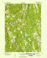
1951 Map of Pound Ridge
USGS Topo · Published 1953About this map
Pound Ridge Reservation and its sprawling network of woodland roads like Honey Hollow Road dominate the northern landscape of this early 1950s survey. The border between Westchester County and Fairfield County bisects a region defined by its hydrography, from the large Trinity Lake and Laurel Reservoir to smaller family-named landmarks like McManus Pond and Gilmore Ponds. This period shows the transition of the Connecticut and New York borderlands into a more settled residential corridor, while maintaining significant institutional and community landmarks such as the Bernadine Convent and Silver Spring Country Club. Local history is deeply etched into the terrain via numerous family burial grounds including Delavan Cem, Hoyt Cem, and Sarles Cem. Small crossroads hamlets like Scotts Corners and High Ridge serve as focal points for a road system that still follows the ridges and valleys of the Mianus and Rippowam drainage basins.
Find a feature on this map
100 named features on this map. Tap any name to fly to it.
Don’t see what you’re looking for? This feature index may not catch every label — zoom into the map to look around manually.
Map Details
Editions of this 1951 Pound Ridge Map
3 editions found
Other maps of this area

1892 · Stamford
USGS Topo · 1:62,500

1892 · Danbury
USGS Topo · 1:62,500

1892 · Norwalk
USGS Topo · 1:62,500

1892 · Carmel
USGS Topo · 1:62,500

1893 · Carmel
USGS Topo · 1:62,500

1893 · Stamford
USGS Topo · 1:62,500

1893 · Norwalk
USGS Topo · 1:62,500

1894 · Carmel
USGS Topo · 1:62,500

1899 · Stamford
USGS Topo · 1:62,500

1915 · Danbury
USGS Topo · 1:62,500