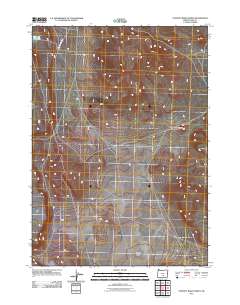
2011 Map of Poverty Basin North
USGS Topo · Published 2011About this map
Doughnut Mountain rises above the expansive terrain of Lake County in this 2011 survey of the high desert landscape. The map centers on the northern portion of Poverty Basin, a geographic depression defined by its subtle drainage patterns and sparse water resources. Human infrastructure is limited to primitive transit routes like BLM Road 6154-0-00, reflecting the managed public lands characteristic of this part of Oregon. Essential water features such as the North DC Waterhole highlight the critical nature of water management for livestock and wildlife in an otherwise arid environment, providing a detailed record of the region's topography and land use at the start of the decade.
Find a feature on this map
4 named features on this map. Tap any name to fly to it.
Don’t see what you’re looking for? This feature index may not catch every label — zoom into the map to look around manually.
Map Details
Editions of this 2011 Poverty Basin North Map
This is the sole edition of this map. No revisions or reprints were ever made.
Other maps of this area

1955 · Crescent
USGS Topo · 1:250,000

1955 · Klamath Falls
USGS Topo · 1:250,000

1957 · Crescent
USGS Topo · 1:250,000

1958 · Crescent
USGS Topo · 1:250,000

1958 · Klamath Falls
USGS Topo · 1:250,000

1970 · Crescent
USGS Topo · 1:250,000

1974 · Lake Abert
USGS Topo · 1:100,000
1984 · Alkali Buttes
USGS Topo · 1:24,000
1984 · Alkali Lake
USGS Topo · 1:24,000
1984 · Goodrich Well
USGS Topo · 1:24,000