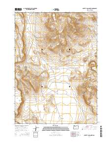
2014 Map of Poverty Basin North
USGS Topo · Published 2014About this map
Poverty Basin dominates this landscape in southeastern Lake County, revealing a region defined by high-desert land management and grazing infrastructure in the early 21st century. The terrain is marked by distinctive volcanic and erosional features such as Doughnut Mtn and the prominent Saunders Rim, while the presence of Poverty Wls points to the critical importance of water resources in this arid environment. A network of utilitarian tracks and routes, including Brim New Lake Road Spur and the curious E Burma, crisscrosses the basins, reflecting the ongoing operations of the Bureau of Land Management. The map also identifies specific land-use areas like Brim Seeding, illustrating how this corner of Oregon is partitioned and managed for range health and livestock.
Find a feature on this map
17 named features on this map. Tap any name to fly to it.
Don’t see what you’re looking for? This feature index may not catch every label — zoom into the map to look around manually.
Map Details
Editions of this 2014 Poverty Basin North Map
This is the sole edition of this map. No revisions or reprints were ever made.
Other maps of this area

1955 · Crescent
USGS Topo · 1:250,000

1955 · Klamath Falls
USGS Topo · 1:250,000

1957 · Crescent
USGS Topo · 1:250,000

1958 · Crescent
USGS Topo · 1:250,000

1958 · Klamath Falls
USGS Topo · 1:250,000

1970 · Crescent
USGS Topo · 1:250,000

1974 · Lake Abert
USGS Topo · 1:100,000
1984 · Alkali Buttes
USGS Topo · 1:24,000
1984 · Alkali Lake
USGS Topo · 1:24,000
1984 · Goodrich Well
USGS Topo · 1:24,000