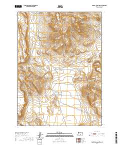
2020 Map of Poverty Basin North
USGS Topo · Published 2020About this map
Poverty Basin forms the central character of this high-desert landscape in Lake County, situated within a vast grid of township and range lines. The terrain is defined by dramatic elevation changes and isolated peaks, most notably Doughnut Mtn in the northeast and the distinctive Saunders Rim which edges the southwestern portion of the sheet. This 2020 U.S. Geological Survey production reveals a landscape dominated by natural features rather than human settlement, where topographic contours trace the complex drainage patterns and ridgelines of the Oregon outback. The map illustrates how public land survey boundaries such as t29s r21e and t29s r22e impose a structured order over the irregular, high-altitude geography of the Great Basin region.
Find a feature on this map
9 named features on this map. Tap any name to fly to it.
Don’t see what you’re looking for? This feature index may not catch every label — zoom into the map to look around manually.
Map Details
Editions of this 2020 Poverty Basin North Map
This is the sole edition of this map. No revisions or reprints were ever made.
Other maps of this area

1955 · Crescent
USGS Topo · 1:250,000

1955 · Klamath Falls
USGS Topo · 1:250,000

1957 · Crescent
USGS Topo · 1:250,000

1958 · Crescent
USGS Topo · 1:250,000

1958 · Klamath Falls
USGS Topo · 1:250,000

1970 · Crescent
USGS Topo · 1:250,000

1974 · Lake Abert
USGS Topo · 1:100,000
1984 · Alkali Buttes
USGS Topo · 1:24,000
1984 · Alkali Lake
USGS Topo · 1:24,000
1984 · Goodrich Well
USGS Topo · 1:24,000