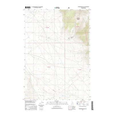
2017 Map of Powderhorn Gulch
USGS Topo · Published 2017About this map
Salmon National Forest defines the high-elevation eastern edge of this Lemhi County landscape, where the terrain drops sharply from mountainous ridgelines into a network of drainage basins. The area is dominated by the seasonal flow of Eighteenmile Cr and its tributaries, including Tenmile Cr and Clear Cr, which carve paths through the dry basins of the Bitterroot Range foothills. This 2017 survey shows a remote area primarily managed for timber and grazing, structured by a sparse network of access routes such as Eighteen Mile Rd and Bull Cr Rd. The intersection of Powderhorn Gulch and Perk Canyon highlights the sharp relief characteristic of the region, where water-carved features like Divide Cr served as natural landmarks for early explorers and surveyors moving through this corner of Idaho.
Find a feature on this map
16 named features on this map. Tap any name to fly to it.
Don’t see what you’re looking for? This feature index may not catch every label — zoom into the map to look around manually.
Map Details
Editions of this 2017 Powderhorn Gulch Map
This is the sole edition of this map. No revisions or reprints were ever made.
Other maps of this area

1955 · Dubois
USGS Topo · 1:250,000

1956 · Leadore
USGS Topo · 1:62,500

1956 · Morrison Lake
USGS Topo · 1:62,500

1956 · Nicholia
USGS Topo · 1:62,500

1957 · Gilmore
USGS Topo · 1:62,500

1958 · Dubois
USGS Topo · 1:250,000

1980 · Leadore
USGS Topo · 1:100,000

1987 · Gilmore
USGS Topo · 1:24,000
1987 · Morrison Lake
USGS Topo · 1:24,000

1987 · Purcell Spring
USGS Topo · 1:24,000