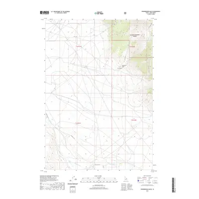
2020 Map of Powderhorn Gulch
USGS Topo · Published 2020About this map
High-country drainage patterns and public lands dominate this section of Salmon National Forest in Lemhi County. The terrain is defined by its namesake Powderhorn Gulch and the deeply cut Perk Canyon, which funnel seasonal runoff toward the broader valley floors. These systems feed into notable watercourses including Eighteenmile Cr, Clear Cr, and Tenmile Cr. The road network is sparse, consisting largely of unpaved access routes like Bull Cr Rd and Eighteen Mile Rd that follow the natural contours of the mountain foothills. This 2020 record illustrates the enduring isolation of this part of Idaho, where land management boundaries for the forest meet the open grazing and riparian corridors of the high desert basins, maintaining a landscape largely unchanged by modern development.
Find a feature on this map
17 named features on this map. Tap any name to fly to it.
Don’t see what you’re looking for? This feature index may not catch every label — zoom into the map to look around manually.
Map Details
Editions of this 2020 Powderhorn Gulch Map
This is the sole edition of this map. No revisions or reprints were ever made.
Other maps of this area

1955 · Dubois
USGS Topo · 1:250,000

1956 · Leadore
USGS Topo · 1:62,500

1956 · Morrison Lake
USGS Topo · 1:62,500

1956 · Nicholia
USGS Topo · 1:62,500

1957 · Gilmore
USGS Topo · 1:62,500

1958 · Dubois
USGS Topo · 1:250,000

1980 · Leadore
USGS Topo · 1:100,000

1987 · Gilmore
USGS Topo · 1:24,000
1987 · Morrison Lake
USGS Topo · 1:24,000

1987 · Purcell Spring
USGS Topo · 1:24,000