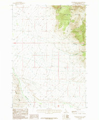
1987 Map of Powderhorn Gulch
USGS Topo · Published 1987About this map
Salmon National Forest dominates the eastern high ground of this Lemhi County landscape, where the terrain drops sharply toward the drainage basins of the west. A network of alpine waterways including Powderhorn Gulch, Tenmile Creek, and Clear Creek carve through the slopes, eventually feeding into the larger valley floor. The presence of several prospects near Tenmile Creek indicates the area's legacy of mineral exploration within the mountainous interior. In the southwestern corner, Eighteenmile Creek follows the base of Center Ridge, while the topographic Divide marks the natural boundary between watersheds. This 1980s-era provisional survey captures a remote wilderness interface defined by its water resources and complex elevation changes, illustrating the transition from protected forest land to the expansive ranching and mining country of central Idaho.
Find a feature on this map
15 named features on this map. Tap any name to fly to it.
Don’t see what you’re looking for? This feature index may not catch every label — zoom into the map to look around manually.
Map Details
Editions of this 1987 Powderhorn Gulch Map
This is the sole edition of this map. No revisions or reprints were ever made.
Other maps of this area

1955 · Dubois
USGS Topo · 1:250,000

1956 · Leadore
USGS Topo · 1:62,500

1956 · Morrison Lake
USGS Topo · 1:62,500

1956 · Nicholia
USGS Topo · 1:62,500

1957 · Gilmore
USGS Topo · 1:62,500

1958 · Dubois
USGS Topo · 1:250,000

1980 · Leadore
USGS Topo · 1:100,000

1987 · Gilmore
USGS Topo · 1:24,000
1987 · Morrison Lake
USGS Topo · 1:24,000

1987 · Purcell Spring
USGS Topo · 1:24,000