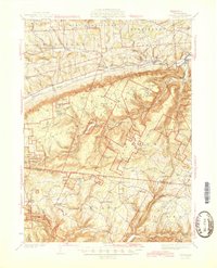
1945 Map of Powell
USGS Topo · Published 1945About this map
Towanda Creek and its many branches like North Branch Towanda Creek dominate the upper half of this mid-century landscape, carving paths through the steep terrain of Bradford and Sullivan Counties. The map reveals a transition from the agricultural settlements of Granville Center and Franklindale in the north to the heavily wooded highlands of the south. A notable cluster of historical infrastructure is found along Schrader Creek, where the former industrial sites of Carbon, Laquin, and Barclay Station speak to a time of intensive resource extraction in the mountains. The southern reaches are defined by a network of family-named peaks and ridges, including Cahill Mtn with its Fire Tower and the remote community of Estella. Social centers of the era are well-documented, from the Friends Meeting House to various rural schoolhouses like Oldland Sch and the already noted East Sch (Abandoned).
Find a feature on this map
96 named features on this map. Tap any name to fly to it.
Don’t see what you’re looking for? This feature index may not catch every label — zoom into the map to look around manually.
Map Details
Editions of this 1945 Powell Map
3 editions found

Other maps of this area

1923 · Towanda
USGS Topo · 1:62,500

1926 · Towanda
USGS Topo · 1:62,500

1927 · Eagles Mere
USGS Topo · 1:48,000

1930 · Warrensville
USGS Topo · 1:62,500

1931 · Troy
USGS Topo · 1:48,000

1932 · Eagle Mere
USGS Topo · 1:62,500

1934 · Warrensville
USGS Topo · 1:62,500

1934 · Laporte
USGS Topo · 1:62,500

1938 · Troy
USGS Topo · 1:62,500

1939 · Sayre
USGS Topo · 1:62,500
Featured Places
- West Burlington Township, PA
- Leroy Township, PA
- Overton Township, PA
- Long Valley, Franklin Township
- Weston, Monroe Township