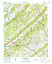
1976 Map of Powell
USGS Topo · Published 1977About this map
Bullrun Valley and the parallel ridges of Beaver Ridge and Copper Ridge dominate the landscape between Clinton and northern Knoxville during this mid-1970s survey. The area shows significant suburban development and established residential clusters like Powell Heights, Broad Acres, and Lakewood. The presence of the Southern Railway and the Clinton Highway underscores the historical transport corridor that linked these communities.
Find a feature on this map
130 named features on this map. Tap any name to fly to it.
Don’t see what you’re looking for? This feature index may not catch every label — zoom into the map to look around manually.
Map Details
Editions of this 1976 Powell Map
2 editions found
Other maps of this area

1886 · Knoxville
USGS Topo · 1:125,000

1892 · Knoxville
USGS Topo · 1:125,000

1893 · Briceville
USGS Topo · 1:125,000

1894 · Knoxville
USGS Topo · 1:125,000

1895 · Loudon
USGS Topo · 1:125,000

1895 · Briceville
USGS Topo · 1:125,000

1895 · Knoxville
USGS Topo · 1:125,000

1896 · Briceville
USGS Topo · 1:125,000

1897 · Maynardville
USGS Topo · 1:125,000

1900 · Maynardville
USGS Topo · 1:125,000