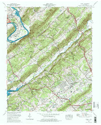
1976 Map of Powell
USGS Topo · Published 1977About this map
Clinton and the surrounding ridgelands of East Tennessee are defined by the parallel courses of Chestnut Ridge, Copper Ridge, and Black Oak Ridge as they stretch toward Knoxville. The Clinch River meanders sharply through the northwest corner, where the Eagle Bend Fish Hatchery sits near a prominent loop of the Melton Hill Lake reservoir. The landscape transitions from the industrial activity near Clinton to the residential growth of Powell and its many subdivisions, including Washington Heights Estates and Idlewild Acres. This era captures the post-war suburbanization of the Beaver Creek valley, while preserving the earlier rural structure of the region. Local history is anchored by numerous small cemeteries and country churches, such as Mount Harmony Ch and the Tennessee Valley Memory Gardens, which serve as vital markers for genealogical research in this corridor between the Southern railroad and Interstate 75.
Find a feature on this map
82 named features on this map. Tap any name to fly to it.
Don’t see what you’re looking for? This feature index may not catch every label — zoom into the map to look around manually.
Map Details
Editions of this 1976 Powell Map
2 editions found
Other maps of this area

1886 · Knoxville
USGS Topo · 1:125,000

1892 · Knoxville
USGS Topo · 1:125,000

1893 · Briceville
USGS Topo · 1:125,000

1894 · Knoxville
USGS Topo · 1:125,000

1895 · Loudon
USGS Topo · 1:125,000

1895 · Briceville
USGS Topo · 1:125,000

1895 · Knoxville
USGS Topo · 1:125,000

1896 · Briceville
USGS Topo · 1:125,000

1897 · Maynardville
USGS Topo · 1:125,000

1900 · Maynardville
USGS Topo · 1:125,000