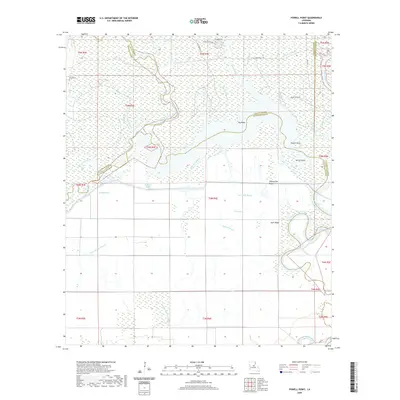
2020 Map of Powell Point
USGS Topo · Published 2020About this map
Saline Bayou and a labyrinth of smaller waterways dominate this low-lying landscape at the junction of Rapides, LaSalle, and Avoyelles Parishes. The map shows a complex hydrological system where Big Saline Bayou and Bushyhead Bayou meander through a series of named elevations and wetlands. Distinctive landforms such as Counterfeit Ridge, Gum Ridge, and Horse Island emerge from the surrounding terrain, providing higher ground in an area defined by water features like Castoff Slough and Jumping Bayou.
Find a feature on this map
44 named features on this map. Tap any name to fly to it.
Don’t see what you’re looking for? This feature index may not catch every label — zoom into the map to look around manually.
Map Details
Editions of this 2020 Powell Point Map
This is the sole edition of this map. No revisions or reprints were ever made.
Other maps of this area

1935 · Tooleys
USGS Topo · 1:62,500

1940 · Marksville
USGS Topo · 1:62,500

1941 · Voorhies
USGS Topo · 1:62,500

1941 · Buckeye
USGS Topo · 1:62,500

1941 · Tooleys
USGS Topo · 1:62,500

1953 · Alexandria
USGS Topo · 1:250,000

1953 · Natchez
USGS Topo · 1:250,000

1955 · Alexandria
USGS Topo · 1:250,000

1956 · Natchez
USGS Topo · 1:250,000

1959 · Natchez
USGS Topo · 1:250,000