
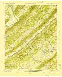
1941 Map of Powell Station
USGS Topo · Published 1952About this map
The Clinch River meanders through the northwest corner of this 1941 landscape, creating a distinct physical boundary marked by Eagle Bend and the TVA Forest Nursery. The terrain is defined by a series of parallel ridges including Pine Ridge, Chestnut Ridge, and Copper Ridge, which channel settlement and transportation into the narrow valleys between them. In Beaver Valley, the community of Powell Station serves as a central hub along the Southern Railway, linked to the surrounding countryside by the historic Emory Road and Clinton Pike. Local industry and social life are anchored by landmarks like Eleanor Mill and Baker Mill, alongside numerous rural congregations such as Lonesome Dove Ch and Haven Chapel. This survey reflects an era of established agrarian communities and early industrial rail connections before modern suburban expansion significantly altered the Knox and Anderson County line.
Find a feature on this map
67 named features on this map. Tap any name to fly to it.
Don’t see what you’re looking for? This feature index may not catch every label — zoom into the map to look around manually.
Map Details
Editions of this 1941 Powell Station Map
2 editions found
Other maps of this area

1886 · Knoxville
USGS Topo · 1:125,000

1892 · Knoxville
USGS Topo · 1:125,000

1893 · Briceville
USGS Topo · 1:125,000

1894 · Knoxville
USGS Topo · 1:125,000

1895 · Loudon
USGS Topo · 1:125,000

1895 · Briceville
USGS Topo · 1:125,000

1895 · Knoxville
USGS Topo · 1:125,000

1896 · Briceville
USGS Topo · 1:125,000

1897 · Maynardville
USGS Topo · 1:125,000

1900 · Maynardville
USGS Topo · 1:125,000