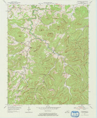
1954 Map of Powersburg
USGS Topo · Published 1969About this map
The rugged boundary of Wayne County and Clinton County is defined by the winding course of Otter Creek and the steep elevation of Edwards Mountain. In the mid-1950s, this area of Kentucky was characterized by numerous small, valley-oriented communities centered around landmarks like Edwards Chapel and Keens Chapel. Education was distributed among several local institutions, including Duncan Valley Sch and Slickford Sch, reflecting a rural social structure where each hollow maintained its own identity. Resource extraction is evident through several Oil Well and Oil Wells sites located near Hidalgo. The landscape is a complex network of named ridges and gaps, such as Hog Mountain and Cherry Mountain Gap, where early geological features like Wind Cave and Blowing Cave are documented near the southern edge of the survey.
Find a feature on this map
60 named features on this map. Tap any name to fly to it.
Don’t see what you’re looking for? This feature index may not catch every label — zoom into the map to look around manually.
Map Details
Editions of this 1954 Powersburg Map
2 editions found
Other maps of this area

1911 · Monticello
USGS Topo · 1:62,500

1914 · Monticello
USGS Topo · 1:62,500

1929 · Byrdstown
USGS Topo · 1:62,500

1934 · Pall Mall
USGS Topo · 1:62,500

1953 · Parnell
USGS Topo · 1:24,000

1953 · Monticello
USGS Topo · 1:24,000

1954 · Parmleysville
USGS Topo · 1:24,000

1954 · Cumberland City
USGS Topo · 1:24,000

1954 · Savage
USGS Topo · 1:24,000

1954 · Powersburg
USGS Topo · 1:24,000