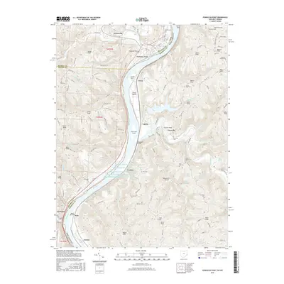
2016 Map of Powhatan Point
USGS Topo · Published 2016About this map
Powhatan Point sits at the northern end of this corridor where the Ohio River carves through the Ohio and West Virginia border. The landscape is defined by its deep ridges and river bottoms, notably Cresap Bottom and Wells Bottom, which supported settlements like Franklin and Clarington. A complex system of water management is evident near Franklin, marked by five successive dams including Quarto Mine Number Four Dam Number One through Number Five. These structures, alongside the presence of industrial sites like Natrium, highlight the area's twentieth-century reliance on heavy industry and mining. Local genealogy is well-documented through numerous hillside burial grounds, such as Saint Johns Cem, Ebenezer Cem, and the Jefferson Stanford Cem near Riggs Knob. The historic Warrior Trail cuts across the center of the map, tracing a path through the high ground of Burch Ridge and past Graysville.
Find a feature on this map
128 named features on this map. Tap any name to fly to it.
Don’t see what you’re looking for? This feature index may not catch every label — zoom into the map to look around manually.
Map Details
Editions of this 2016 Powhatan Point Map
This is the sole edition of this map. No revisions or reprints were ever made.
Other maps of this area

1903 · Littleton
USGS Topo · 1:62,500

1904 · Cameron
USGS Topo · 1:62,500

1905 · Littleton
USGS Topo · 1:62,500

1905 · Clarington
USGS Topo · 1:62,500

1906 · New Martinsville
USGS Topo · 1:62,500

1924 · New Martinsville
USGS Topo · 1:62,500

1924 · Littleton
USGS Topo · 1:62,500

1926 · Littleton
USGS Topo · 1:62,500

1926 · New Martinsville
USGS Topo · 1:62,500

1935 · Cameron
USGS Topo · 1:62,500