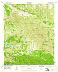
1952 Map of Pozo
USGS Topo · Published 1961About this map
The Salinas River headwaters and the sprawling backcountry of the Los Padres National Forest anchor this 1950s-era study of San Luis Obispo County. The tiny community of Pozo serves as the central hub, home to the Pozo Sch and surrounded by a landscape of rugged canyons and family-named landmarks like Pippin Corner and Wilson Corner. To the west, the Salinas Reservoir stands as a significant hydrological feature, while the southeastern reaches are dominated by the high terrain of the Garcia National Forest.
Find a feature on this map
59 named features on this map. Tap any name to fly to it.
Don’t see what you’re looking for? This feature index may not catch every label — zoom into the map to look around manually.
Map Details
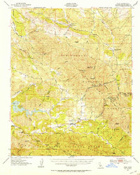
Editions of this 1952 Pozo Map
3 editions found

Other maps of this area

1897 · San Luis Obispo
USGS Topo · 1:62,500

1897 · Arroyo Grande
USGS Topo · 1:62,500

1900 · San Luis
USGS Topo · 1:125,000

1914 · Cholame
USGS Topo · 1:125,000

1915 · Cholame
USGS Topo · 1:125,000

1917 · Cholame
USGS Topo · 1:125,000

1919 · Paso Robles
USGS Topo · 1:62,500

1922 · Pozo
USGS Topo · 1:62,500

1922 · Nipomo
USGS Topo · 1:62,500

1932 · La Panza
USGS Topo · 1:48,000