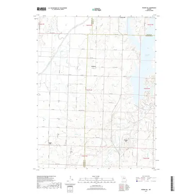
2017 Map of Prairie Hill
USGS Topo · Published 2017About this map
Thomas Hill Reservoir dominates the eastern landscape of this Missouri quadrangle, where the borders of Macon, Randolph, and Chariton counties converge. This 2017 survey shows a region defined by its water systems, from the broad Chariton River in the northwest to the Middle Fork Little Chariton River feeding the reservoir. Small rural settlements like Hubbard, Kaseyville, and Thomas Hill are connected by a network of county roads such as State Hwy T and Co Rd A1. For genealogists and local historians, the map provides specific locations for family resting places like Fawks Cem and Prairie Hill Cem near the community of Prairie Hill. The terrain is marked by numerous seasonal drainages, including Puzzle Cr, Kelley Br, and Muncas Cr, illustrating the complex local hydrology that shapes the agricultural plots and homesteads of the area.
Find a feature on this map
64 named features on this map. Tap any name to fly to it.
Don’t see what you’re looking for? This feature index may not catch every label — zoom into the map to look around manually.
Map Details
Editions of this 2017 Prairie Hill Map
This is the sole edition of this map. No revisions or reprints were ever made.
Other maps of this area

1890 · Glasgow
USGS Topo · 1:125,000

1953 · Moberly
USGS Topo · 1:250,000

1953 · Huntsville
USGS Topo · 1:24,000

1953 · Bevier South
USGS Topo · 1:24,000

1953 · College Mound
USGS Topo · 1:24,000

1953 · Clifton Hill
USGS Topo · 1:24,000

1953 · Prairie Hill
USGS Topo · 1:24,000

1953 · Lagonda
USGS Topo · 1:24,000

1953 · Wien
USGS Topo · 1:24,000

1953 · Bynumville
USGS Topo · 1:24,000