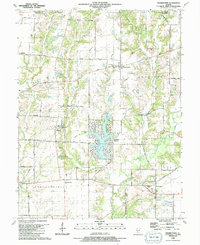
1990 Map of Prairietown
USGS Topo · Published 1991About this map
The agricultural lands along the border of Madison and Macoupin counties are defined here by a network of family-named roads and rural institutions. The community of Prairietown serves as a central hub, anchored by St Peter Ch and its accompanying St Peter Sch, while smaller settlements like Dorsey, Midway, and Carpenter dot the surrounding townships of Moro and Fort Russell. The landscape is bisected by the winding courses of Cahokia Creek and Paddock Creek, with the significant residential development of Holiday Shores centered around Holiday Lake. Genealogists will find a wealth of local history in the numerous small burial grounds scattered across the quadrangle, including the Liberty Prairie Cem, Zimmerman Cem, and the Belt Cem. The infrastructure of the era is evident in the numerous pipelines crossing the fields and the Radio Tower near the lake, reflecting the late 20th-century transition of this rural Illinois landscape.
Find a feature on this map
58 named features on this map. Tap any name to fly to it.
Don’t see what you’re looking for? This feature index may not catch every label — zoom into the map to look around manually.
Map Details
Editions of this 1990 Prairietown Map
This is the sole edition of this map. No revisions or reprints were ever made.
Other maps of this area

1912 · Gillespie
USGS Topo · 1:62,500

1915 · Gillespie
USGS Topo · 1:62,500

1925 · Brighton
USGS Topo · 1:62,500

1927 · Alton
USGS Topo · 1:62,500

1927 · Edwardsville
USGS Topo · 1:62,500

1928 · Brighton
USGS Topo · 1:62,500

1932 · Edwardsville
USGS Topo · 1:62,500

1934 · Alton
USGS Topo · 1:62,500

1948 · Quincy
USGS Topo · 1:250,000

1948 · Wood River
USGS Topo · 1:24,000