
1955 Map of Pratt
USGS Topo · Published 1968About this map
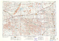
Arkansas River and Cimarron River drainage basins define the southern Kansas landscape in this mid-century survey, revealing a region defined by agricultural grid lines and an extensive energy infrastructure. Numerous oil wells and designated oil fields are scattered across the plains, particularly south of the Medicine Lodge River. The mapping shows a mature transportation network where the Atchison Topeka and Santa Fe and Chicago Rock Island and Pacific railroads intersect at key shipping hubs like Pratt and Dodge City.
Find a feature on this map
137 named features on this map. Tap any name to fly to it.
Don’t see what you’re looking for? This feature index may not catch every label — zoom into the map to look around manually.
Map Details
Editions of this 1955 Pratt Map
3 editions found
Other maps of this area

1889 · Anthony
USGS Topo · 1:125,000

1889 · Cheney
USGS Topo · 1:125,000

1889 · Larned
USGS Topo · 1:125,000

1889 · Caldwell
USGS Topo · 1:125,000

1889 · Kinsley
USGS Topo · 1:125,000

1891 · Great Bend
USGS Topo · 1:125,000

1891 · Medicine Lodge
USGS Topo · 1:125,000

1891 · Larned
USGS Topo · 1:125,000

1891 · Hutchinson
USGS Topo · 1:125,000

1891 · Cheney
USGS Topo · 1:125,000