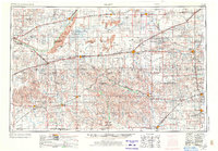
1955 Map of Pratt
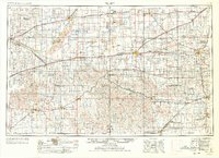
USGS Topo · Published 1973About this map
The Arkansas River and Rattlesnake Creek define the hydraulic character of this South Central Kansas landscape, which sits at a mid-century transition between traditional agriculture and growing infrastructure. The map reveals a dense network of early rail lines including the Atchison Topeka and Santa Fe and the Chicago Rock Island and Pacific, which connect dozens of grain-stop settlements like Zenith, Belpre, and Partridge.
Find a feature on this map
128 named features on this map. Tap any name to fly to it.
Don’t see what you’re looking for? This feature index may not catch every label — zoom into the map to look around manually.
Map Details
Editions of this 1955 Pratt Map
3 editions found

Other maps of this area

1889 · Anthony
USGS Topo · 1:125,000

1889 · Cheney
USGS Topo · 1:125,000

1889 · Larned
USGS Topo · 1:125,000

1889 · Caldwell
USGS Topo · 1:125,000

1889 · Kinsley
USGS Topo · 1:125,000

1891 · Great Bend
USGS Topo · 1:125,000

1891 · Medicine Lodge
USGS Topo · 1:125,000

1891 · Larned
USGS Topo · 1:125,000

1891 · Hutchinson
USGS Topo · 1:125,000

1891 · Cheney
USGS Topo · 1:125,000