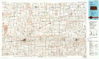
1985 Map of Pratt
USGS Topo · Published 1990About this map
Pratt Sandhills State Wildlife Area and the State Fish Hatchery anchor this mid-1980s landscape across the transition from Stafford into Pratt and Kingman counties. The regional geography is defined by the east-flowing North Fork Ninnescah River and South Fork Ninnescah River, which feed toward Cheney Lake. Infrastructure of the era is dominated by the Atchison Topeka and Santa Fe and Missouri Pacific railroads, which historically dictated the placement of agricultural hubs like Stafford, Cunningham, and Macksville. The grid-patterned sections reveal a high density of rural townships such as Rose Valley, Dresden, and Fairview, while local landmarks like Stafford Cem and the Pilot Knob terrain feature provide specific points of interest for genealogical and topographical research.
Find a feature on this map
95 named features on this map. Tap any name to fly to it.
Don’t see what you’re looking for? This feature index may not catch every label — zoom into the map to look around manually.
Map Details
Editions of this 1985 Pratt Map
2 editions found
Other maps of this area

1889 · Anthony
USGS Topo · 1:125,000

1889 · Cheney
USGS Topo · 1:125,000

1889 · Larned
USGS Topo · 1:125,000

1889 · Caldwell
USGS Topo · 1:125,000

1889 · Kinsley
USGS Topo · 1:125,000

1891 · Great Bend
USGS Topo · 1:125,000

1891 · Medicine Lodge
USGS Topo · 1:125,000

1891 · Larned
USGS Topo · 1:125,000

1891 · Hutchinson
USGS Topo · 1:125,000

1891 · Cheney
USGS Topo · 1:125,000