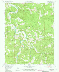
1951 Map of Prescott
USGS Topo · Published 1981About this map
The Big Piney River carves a winding path through the northern half of this Missouri Ozarks landscape, flanked by prominent landmarks like Narrow Gap Bluff and Bell Bluff. The terrain is defined by a dense network of timbered ridges and hollows, such as Elmo Ridge and Steam Mill Hollow, within the Mark Twain National Forest. The settlement of Prescott serves as a local anchor, while the surrounding rural landscape in Lynch and Sherrill townships is dotted with centers of early community life. Genealogists will find several burial sites and education landmarks, including Antioch Cem, Cavaness Cem, and the Venable Sch. The mapping records numerous natural springs like Boiling Spring and Strawberry Spring, which likely served as vital water sources for the scattered homesteads of the mid-20th century.
Find a feature on this map
39 named features on this map. Tap any name to fly to it.
Don’t see what you’re looking for? This feature index may not catch every label — zoom into the map to look around manually.
Map Details
Editions of this 1951 Prescott Map
5 editions found
Other maps of this area

1937 · Edgar Springs
USGS Topo · 1:48,000

1941 · Big Piney
USGS Topo · 1:62,500

1941 · Bado
USGS Topo · 1:62,500

1943 · Big Piney
USGS Topo · 1:62,500

1943 · Bado
USGS Topo · 1:62,500

1945 · Edgar Springs
USGS Topo · 1:62,500

1949 · Rolla
USGS Topo · 1:250,000

1951 · Licking
USGS Topo · 1:24,000

1951 · Raymondville
USGS Topo · 1:24,000

1951 · Prescott
USGS Topo · 1:24,000