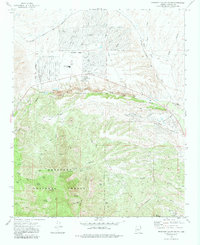
1973 Map of Prescott Valley South
USGS Topo · Published 1983About this map
Prescott Valley appears in the early 1970s as a burgeoning residential grid bounded by the Atchison Topeka and Santa Fe railroad to the north and the expansive Prescott National Forest to the south. The transition from planned suburban streets like Loos Drive and Spouse Drive to the industrial and mineral landscape of the Doodlebug Diggings highlights the area's mixed economic identity. While the Lake Valley Sch and a local Golf Course indicate growing community infrastructure, the terrain remains deeply marked by its mining history, evidenced by the Gravel Pit and numerous Prospect markings.
Find a feature on this map
69 named features on this map. Tap any name to fly to it.
Don’t see what you’re looking for? This feature index may not catch every label — zoom into the map to look around manually.
Map Details
Editions of this 1973 Prescott Valley South Map
2 editions found
Other maps of this area

1887 · Prescott
USGS Topo · 1:250,000

1892 · Prescott
USGS Topo · 1:250,000

1903 · Bradshaw Mountains
USGS Topo · 1:125,000

1905 · Jerome
USGS Topo · 1:125,000

1944 · Mingus Mountain
USGS Topo · 1:62,500

1947 · Mingus Mtn
USGS Topo · 1:62,500

1947 · Mayer
USGS Topo · 1:62,500

1947 · Mt. Union
USGS Topo · 1:62,500

1947 · Prescott
USGS Topo · 1:62,500

1948 · Mt. Union
USGS Topo · 1:63,360
Featured Places
- Prescott Valley, AZ
- Dewey-Humboldt, AZ
- Blue Hills Farms, Dewey-Humboldt
- Yavapai County, AZ
- United States