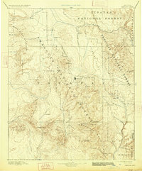
1892 Map of Prescott
USGS Topo · Published 1927About this map
Prescott serves as the central hub of this late-19th-century reconnaissance, situated just east of the critical military outpost at Fort Whipple. The landscape is dominated by the complex interplay of high valleys and prominent ranges, including the Bradshaw Mountains and the Santa Maria Mountains. The settlement pattern reflects the era’s mining and ranching foundations, with isolated outposts like Bumble-bee, Stanton, and Marysville dotting the terrain. Drainage systems like the Hassayampa River and Agua Fria provided essential water in this arid territory, while the expansive Tusayan National Forest and Prescott National Forest define the protected timberlands. The survey, conducted in 1885, captures the region's geography before modern development, preserving the locations of family-named landmarks such as Del Pasco Mt and Wassons Peak alongside early valley settlements like Skull Valley and Peeples Valley.
Find a feature on this map
66 named features on this map. Tap any name to fly to it.
Don’t see what you’re looking for? This feature index may not catch every label — zoom into the map to look around manually.
Map Details
Editions of this 1892 Prescott Map
5 editions found
Other maps of this area

1886 · Diamond Creek
USGS Topo · 1:250,000

1886 · San Francisco Mtns
USGS Topo · 1:250,000

1886 · Chino
USGS Topo · 1:250,000

1887 · Verde
USGS Topo · 1:250,000

1887 · Prescott
USGS Topo · 1:250,000

1891 · San Francisco Mtns
USGS Topo · 1:250,000

1891 · Chino
USGS Topo · 1:250,000

1892 · Verde
USGS Topo · 1:250,000

1892 · Diamond Creek
USGS Topo · 1:250,000

1892 · Prescott
USGS Topo · 1:250,000