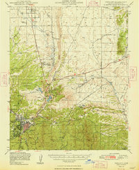
1948 Map of Prescott
USGS Topo · Published 1948About this map
Prescott sits at the intersection of high desert and forest in the late 1940s, anchored by the Whipple Military Reservation and the Yavapai Ind Res. The landscape is a complex network of ranching, mining, and transportation, where the Atchison Topeka and Santa Fe railroad serves key points like Granite Siding and Entro. Water management is central to life here, evidenced by the Chino Valley Irrigation Ditch and reservoirs like Willow Cr Reservoir and Watson L feeding into Granite Creek. To the east, the Agua Fria River and Lynx Creek drain the slopes near Glassford Hill. The survey captures the transition from historic resource extraction at the Old Hopkins Mine to modern infrastructure such as the Prescott Municipal Airport and a Radio Direction Finder, reflecting the city's growth as a regional hub.
Find a feature on this map
48 named features on this map. Tap any name to fly to it.
Don’t see what you’re looking for? This feature index may not catch every label — zoom into the map to look around manually.
Map Details
Editions of this 1948 Prescott Map
4 editions found

Other maps of this area

1887 · Prescott
USGS Topo · 1:250,000

1892 · Prescott
USGS Topo · 1:250,000

1903 · Bradshaw Mountains
USGS Topo · 1:125,000

1903 · Congress
USGS Topo · 1:125,000

1904 · Congress
USGS Topo · 1:125,000

1905 · Jerome
USGS Topo · 1:125,000

1944 · Clarkdale
USGS Topo · 1:48,000

1944 · Mingus Mountain
USGS Topo · 1:62,500

1947 · Mingus Mtn
USGS Topo · 1:62,500

1947 · Mayer
USGS Topo · 1:62,500