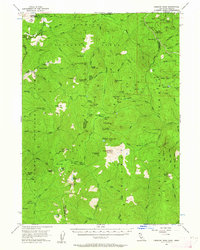
1956 Map of Preston Peak
USGS Topo · Published 1962About this map
Preston Peak stands as the dominant summit in this high-elevation landscape of the Siskiyou National Forest, straddling the border between California and Oregon. The survey reveals a network of high-country outposts and seasonal destinations including Porters Camp, Camp Chicago, and Bell Echo Camp, suggesting a mid-century period of active forest management and recreation. Transportation in this wilderness is defined by the Redwood Highway in the northwest corner, contrasted by numerous unnamed trails and a Jeep Trail that penetrate the interior. Notable geological and water features such as the Devils Punchbowl and the headwaters of the Middle Fork Smith River drain the rugged ridges. Local history is preserved in named sites like Poker Flat and Prescott Cabin, which provide evidence of earlier settlement or specialized mountain use during this era.
Find a feature on this map
89 named features on this map. Tap any name to fly to it.
Don’t see what you’re looking for? This feature index may not catch every label — zoom into the map to look around manually.
Map Details
Editions of this 1956 Preston Peak Map
2 editions found

Other maps of this area

1908 · Grants Pass
USGS Topo · 1:125,000

1914 · Seiad
USGS Topo · 1:125,000

1917 · Kerby
USGS Topo · 1:125,000

1918 · Kerby
USGS Topo · 1:125,000

1922 · Preston Peak
USGS Topo · 1:125,000

1922 · Seiad
USGS Topo · 1:125,000

1945 · Ship Mountain
USGS Topo · 1:62,500

1945 · Kerby
USGS Topo · 1:125,000

1945 · Gasquet
USGS Topo · 1:62,500

1948 · Weed
USGS Topo · 1:250,000