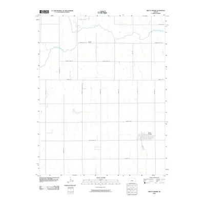
2009 Map of Pretty Prairie
USGS Topo · Published 2009About this map
Pretty Prairie sits at the heart of this Reno County landscape, where the town's grid plan is flanked by the winding course of the North Fork Ninnescah River. This 2009 survey reveals the highly organized section-line road network characteristic of the Kansas plains, with named routes like Pretty Prairie Rd and Silver Lake Rd connecting the agricultural blocks. The northern portion of the quadrangle is defined by the river’s drainage basin, including the confluence of Irish Creek. For local history researchers, the Township Cemetery located near Pleasant Valley Rd serves as a significant genealogical landmark. The map documents a classic Midwestern rural layout, where the built environment of the town contrasts with the vast, hydrology-carved reaches of the river valley.
Find a feature on this map
21 named features on this map. Tap any name to fly to it.
Don’t see what you’re looking for? This feature index may not catch every label — zoom into the map to look around manually.
Map Details
Editions of this 2009 Pretty Prairie Map
This is the sole edition of this map. No revisions or reprints were ever made.
Other maps of this area

1889 · Cheney
USGS Topo · 1:125,000

1891 · Cheney
USGS Topo · 1:125,000

1892 · Kingman
USGS Topo · 1:125,000

1894 · Kingman
USGS Topo · 1:125,000

1901 · Cheney
USGS Topo · 1:125,000

1955 · Wichita
USGS Topo · 1:250,000

1955 · Pratt
USGS Topo · 1:250,000

1958 · Wichita
USGS Topo · 1:250,000

1959 · Pratt
USGS Topo · 1:250,000
1961 · Elmer
USGS Topo · 1:24,000