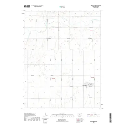
2018 Map of Pretty Prairie
USGS Topo · Published 2018About this map
Pretty Prairie sits at the heart of this Reno County landscape, where a dense grid of residential streets including Main St, Christy St, and E Booth St marks the town's footprint. The surrounding terrain is defined by the winding course of the North Fork Ninnescah River and its tributary Irish Creek in the northwest, which break the otherwise regular sectional grid of the Kansas plains. Local history is anchored by the presence of Township Cemetery and Baker Cemetery, both situated north of the town center along W Pleasant Valley Rd. This 2018 survey reveals a landscape of modern agriculture where traditional names like Fountain Green Rd and High Point Rd continue to define the rural movement across the territory.
Find a feature on this map
30 named features on this map. Tap any name to fly to it.
Don’t see what you’re looking for? This feature index may not catch every label — zoom into the map to look around manually.
Map Details
Editions of this 2018 Pretty Prairie Map
This is the sole edition of this map. No revisions or reprints were ever made.
Other maps of this area

1889 · Cheney
USGS Topo · 1:125,000

1891 · Cheney
USGS Topo · 1:125,000

1892 · Kingman
USGS Topo · 1:125,000

1894 · Kingman
USGS Topo · 1:125,000

1901 · Cheney
USGS Topo · 1:125,000

1955 · Wichita
USGS Topo · 1:250,000

1955 · Pratt
USGS Topo · 1:250,000

1958 · Wichita
USGS Topo · 1:250,000

1959 · Pratt
USGS Topo · 1:250,000
1961 · Elmer
USGS Topo · 1:24,000