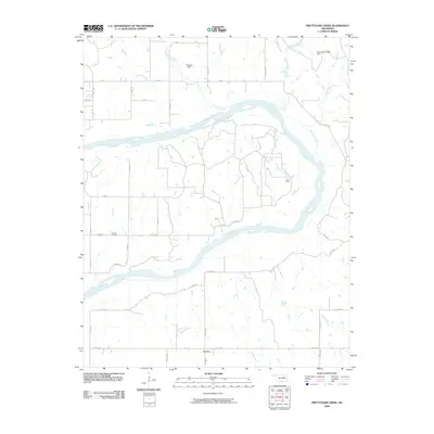
2009 Map of Prettyhair Creek
USGS Topo · Published 2009About this map
The Arkansas River winds through this landscape, carving a deep curve around the settlement of Big Bend. This 2009 survey reveals a rural landscape defined by ranching and water management, where the Bar L Ranch sits near the junction of several drainage systems. Local history is anchored at the Bressie Cemetery, while the northern terrain is marked by significant hydrological features including Prettyhair Creek, Simpkins Creek, and the Ocheleta Dam. The map also identifies a specific area of topographic interest known as the Badlands located south of the main river channel. A complex network of numbered county roads, such as Co Rd 6150 and 80 Rd, connects the scattered farmsteads and ranchlands, providing a clear picture of the land division and access points in Osage County at the start of the twenty-first century.
Find a feature on this map
38 named features on this map. Tap any name to fly to it.
Don’t see what you’re looking for? This feature index may not catch every label — zoom into the map to look around manually.
Map Details
Editions of this 2009 Prettyhair Creek Map
This is the sole edition of this map. No revisions or reprints were ever made.
Other maps of this area

1930 · Pawnee
USGS Topo · 1:62,500

1936 · Belford
USGS Topo · 1:62,500

1936 · Pawnee
USGS Topo · 1:62,500

1955 · Enid
USGS Topo · 1:250,000

1958 · Enid
USGS Topo · 1:250,000

1963 · Charley Creek
USGS Topo · 1:24,000

1964 · Charley Creek NE
USGS Topo · 1:24,000

1968 · Ponca City SE
USGS Topo · 1:24,000
1968 · Ponca City
USGS Topo · 1:24,000

1972 · Morrison NE
USGS Topo · 1:24,000