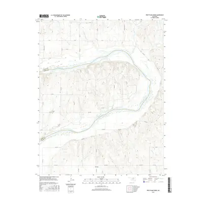
2016 Map of Prettyhair Creek
USGS Topo · Published 2016About this map
The Arkansas River meanders through this portion of the Oklahoma plains, defining the boundary between Osage and Noble counties. The landscape is characterized by its wide river bends, most notably the prominent Big Bend, and the dissected topography of the Badlands. Named watercourses including Prettyhair Creek, Simpkins Cr, and Little Drum Cr drain into the river system, carving small valleys through the rural acreage. The human imprint on the land is primarily agricultural and commemorative, marked by scattered country roads like 9 Mile Rd and Co Rd 6210. Local history and genealogy are anchored by the presence of Bressie Cem and Pixley Cem, which serve as quiet landmarks among the section lines and pastures of this river-centered landscape.
Find a feature on this map
42 named features on this map. Tap any name to fly to it.
Don’t see what you’re looking for? This feature index may not catch every label — zoom into the map to look around manually.
Map Details
Editions of this 2016 Prettyhair Creek Map
This is the sole edition of this map. No revisions or reprints were ever made.
Other maps of this area

1930 · Pawnee
USGS Topo · 1:62,500

1936 · Belford
USGS Topo · 1:62,500

1936 · Pawnee
USGS Topo · 1:62,500

1955 · Enid
USGS Topo · 1:250,000

1958 · Enid
USGS Topo · 1:250,000

1963 · Charley Creek
USGS Topo · 1:24,000

1964 · Charley Creek NE
USGS Topo · 1:24,000

1968 · Ponca City SE
USGS Topo · 1:24,000
1968 · Ponca City
USGS Topo · 1:24,000

1972 · Morrison NE
USGS Topo · 1:24,000