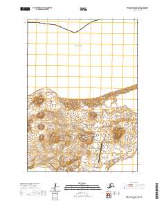
2020 Map of Pribilof Islands D-4 SW
USGS Topo · Published 2020About this map
St. Paul serves as the focal point of this island landscape, where the volcanic topography of the Pribilof Islands meets the Bering Sea. The map reveals a cluster of prominent cinder cones and elevations including Pot Hill, Bogoslof Hill, and Polovina Hill, which define the interior terrain. A network of specialized access roads, such as the Kamanista/Fedoreka Well Access Road and the Aalak Landfill Road, connects the settlement and the St Paul Island Airport to the more remote reaches of the island. Coastal features like North Point and the shifting Polovina Sands illustrate the dynamic interface between land and sea. This 2020 survey documents the modern infrastructure and natural landmarks of the area, from the small settlement of Kamenisti to the broad reach of North Bay, providing a contemporary record of this remote subarctic environment.
Find a feature on this map
30 named features on this map. Tap any name to fly to it.
Don’t see what you’re looking for? This feature index may not catch every label — zoom into the map to look around manually.
Map Details
Editions of this 2020 Pribilof Islands D-4 SW Map
This is the sole edition of this map. No revisions or reprints were ever made.
Other maps of this area
1948 · Pribilof Islands
USGS Topo · 1:250,000
1949 · Pribilof Islands
USGS Topo · 1:250,000
1958 · Pribilof Islands
USGS Topo · 1:250,000
1969 · Pribilof Islands
USGS Topo · 1:250,000
2001 · Saint Paul Island East
USGS Topo · 1:25,000
2001 · Saint Paul Island West
USGS Topo · 1:25,000
2020 · Pribilof Islands D-5 SE
USGS Topo · 1:25,000
2020 · Pribilof Islands D-4 SE
USGS Topo · 1:25,000
2020 · Pribilof Islands C-4 NE
USGS Topo · 1:25,000
2020 · Pribilof Islands C-5 NE
USGS Topo · 1:25,000