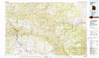
1980 Map of Price
USGS Topo · Published 1992About this map
The Price River valley serves as the industrial and agricultural heart of this region, where the Denver and Rio Grande Western Railroad and the Utah Railway navigate the narrow corridors between the Wasatch Plateau and the Book Cliffs. In the early 1980s, this landscape was defined by the deep-seated relationship between coal mining and settlement. A string of mountain mining towns, including Kenilworth, Standardville, Royal, and Castle Gate, flank the canyon walls north of Helper. To the east, the extensive operations of the Sunnyside Mine, Horse Canyon Mine, and Geneva Mine demonstrate the massive scale of extraction on the Tavaputs Plateau. While Price and Wellington occupy the more open valley floor, the map reveals a rugged backcountry of long ridges like Steer Ridge and Argyle Ridge, as well as the remote drainage of Nine Mile Creek winding through the Bad Land Cliffs.
Find a feature on this map
112 named features on this map. Tap any name to fly to it.
Don’t see what you’re looking for? This feature index may not catch every label — zoom into the map to look around manually.
Map Details
Editions of this 1980 Price Map
3 editions found
Other maps of this area

1885 · Salt Lake
USGS Topo · 1:250,000

1885 · Manti
USGS Topo · 1:250,000

1885 · East Tavaputs
USGS Topo · 1:250,000

1885 · Ashley
USGS Topo · 1:250,000

1885 · Uinta
USGS Topo · 1:250,000

1886 · Price River
USGS Topo · 1:250,000

1895 · Manti
USGS Topo · 1:250,000

1896 · Price River
USGS Topo · 1:250,000

1907 · Strawberry Valley
USGS Topo · 1:125,000

1909 · Strawberry Valley
USGS Topo · 1:125,000