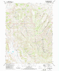
1986 Map of Price Creek
USGS Topo · Published 1986About this map
The Danforth Hills define the rugged character of this northwestern Colorado landscape, serving as a backdrop for the extensive energy exploration of the 1980s. The map documents numerous drill holes and oil wells scattered across the upland plateaus and deep drainage cuts, illustrating the industrial footprint of the period. In the lower elevations, Price Creek and its associated Coyote Channel Basin Creek provide the primary water sources for this arid region, where ranching infrastructure like a coral and a storage bin appear alongside natural features like Deep Springs. The naming conventions of the gulches and canyons, such as Ben Mauldin Gulch and Hale Gulch, reflect the localized history of settlement and grazing in the Price Creek area before and during the height of regional resource extraction.
Find a feature on this map
26 named features on this map. Tap any name to fly to it.
Don’t see what you’re looking for? This feature index may not catch every label — zoom into the map to look around manually.
Map Details
Editions of this 1986 Price Creek Map
This is the sole edition of this map. No revisions or reprints were ever made.
Other maps of this area

1907 · White River
USGS Topo · 1:125,000

1910 · Danforth Hills
USGS Topo · 1:125,000

1910 · White River
USGS Topo · 1:125,000

1912 · Meeker
USGS Topo · 1:62,500

1912 · Axial
USGS Topo · 1:62,500

1914 · Meeker
USGS Topo · 1:62,500

1914 · Axial
USGS Topo · 1:62,500

1954 · Vernal
USGS Topo · 1:250,000

1954 · Craig
USGS Topo · 1:250,000

1957 · Craig
USGS Topo · 1:250,000