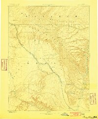
1886 Map of Price River
USGS Topo · Published 1901About this map
The Denver and Rio Grande Western R.R. dictates the rhythm of settlement across this territory, threading through the narrow passages of Castle Valley to connect mountain mining camps and valley outposts. From the northern gate at Castle Gate, the line follows the winding Price River past the emerging hub of Price and the mining community at Sunny Side. This Powell Survey reconnaissance provides a clear view of the complex topography defined by the Roan or Book Cliffs and the deep incision of Desolation Canon along the eastern edge. Remote crossings and natural landmarks like Gunnison Butte and Cottonwood Springs speak to the early infrastructure of the region before the arrival of modern highways, while the Beckwith Plateau stands as a massive barrier between the rail corridor and the canyonlands of the Green River.
Find a feature on this map
30 named features on this map. Tap any name to fly to it.
Don’t see what you’re looking for? This feature index may not catch every label — zoom into the map to look around manually.
Map Details
Editions of this 1886 Price River Map
4 editions found
Other maps of this area

1885 · San Rafael
USGS Topo · 1:250,000

1885 · Salt Lake
USGS Topo · 1:250,000

1885 · Manti
USGS Topo · 1:250,000

1885 · East Tavaputs
USGS Topo · 1:250,000

1885 · La Sal
USGS Topo · 1:250,000

1885 · Ashley
USGS Topo · 1:250,000

1885 · Fish Lake
USGS Topo · 1:250,000

1885 · Uinta
USGS Topo · 1:250,000

1886 · Price River
USGS Topo · 1:250,000

1895 · Manti
USGS Topo · 1:250,000