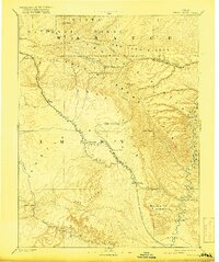
1886 Map of Price River
USGS Topo · Published 1917About this map
Denver & Rio Grande R R tracks follow the winding course of the Price River, creating a vital transportation corridor through the central Utah landscape during the late nineteenth century. This Powell Survey reconnaissance identifies several early rail stops and settlements, including Castle Gate, Sunny Side, and Price, which served as critical nodes for local trade and industry. To the east, the dramatic relief of the Roan or Book Cliffs and the Bad Land Cliffs dominate the horizon, leading toward the deep incision of Desolation Canyon on the Green River. The map illustrates a stark geographic transition from the high Wasatch Plateau down into the Gunnison Valley, recording the early boundaries of the Uinta National Forest and the isolated outposts like Grassy Trail and Lower Crossing that defined life in Emery County.
Find a feature on this map
30 named features on this map. Tap any name to fly to it.
Don’t see what you’re looking for? This feature index may not catch every label — zoom into the map to look around manually.
Map Details
Editions of this 1886 Price River Map
4 editions found
Other maps of this area

1885 · San Rafael
USGS Topo · 1:250,000

1885 · Salt Lake
USGS Topo · 1:250,000

1885 · Manti
USGS Topo · 1:250,000

1885 · East Tavaputs
USGS Topo · 1:250,000

1885 · La Sal
USGS Topo · 1:250,000

1885 · Ashley
USGS Topo · 1:250,000

1885 · Fish Lake
USGS Topo · 1:250,000

1885 · Uinta
USGS Topo · 1:250,000

1886 · Price River
USGS Topo · 1:250,000

1895 · Manti
USGS Topo · 1:250,000