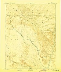
1886 Map of Price River
USGS Topo · Published 1908About this map
The Denver and Rio Grande Western RR cuts through the heart of this landscape, tracing the descent from Castle Gate into the expansive Castle Valley. Surveyed during the era of major Western exploration by the Powell Survey, the map captures early settlements like Price and Castle Dale before the full expansion of the regional coal industry. The geography is dominated by a succession of dramatic plateaus and escarpments, including the Roan or Book Cliffs and the Brown Plateau, which separate the northern canyons from the Gunnison Valley to the south.
Find a feature on this map
31 named features on this map. Tap any name to fly to it.
Don’t see what you’re looking for? This feature index may not catch every label — zoom into the map to look around manually.
Map Details
Editions of this 1886 Price River Map
4 editions found
Other maps of this area

1885 · San Rafael
USGS Topo · 1:250,000

1885 · Salt Lake
USGS Topo · 1:250,000

1885 · Manti
USGS Topo · 1:250,000

1885 · East Tavaputs
USGS Topo · 1:250,000

1885 · La Sal
USGS Topo · 1:250,000

1885 · Ashley
USGS Topo · 1:250,000

1885 · Fish Lake
USGS Topo · 1:250,000

1885 · Uinta
USGS Topo · 1:250,000

1886 · Price River
USGS Topo · 1:250,000

1895 · Manti
USGS Topo · 1:250,000