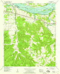
1954 Map of Pride
USGS Topo · Published 1958About this map
Colbert Steam Plant stands as a massive industrial presence along the Tennessee River in this mid-1950s survey of the Alabama-Tennessee borderlands. The landscape is defined by the heavy infrastructure of the Southern Railway and the Lee Highway corridor, which parallel the river and connect the settlement of Pride. To the north, Pickwick Lake surrounds prominent landforms like Sevenmile Island and Buck Island, marking the regulated water levels of the era. South of the industrial riverfront, the terrain rises into the densely wooded ridges of Pride Mountain and Wheeler Mountain. This area is dotted with small rural landmarks essential for genealogical research, including Zion Ch, Nazareth Ch, and several family-named cemeteries like Holland Cem and Basden Cem. The map captures a transition between the heavy power generation at the river's edge and the traditional agricultural and timber lands of the interior ridges.
Find a feature on this map
63 named features on this map. Tap any name to fly to it.
Don’t see what you’re looking for? This feature index may not catch every label — zoom into the map to look around manually.
Map Details
Editions of this 1954 Pride Map
This is the sole edition of this map. No revisions or reprints were ever made.
Other maps of this area

1914 · Muscle Shoals
USGS Topo · 1:48,000

1916 · Muscle Shoals
USGS Topo · 1:62,500

1924 · Tuscumbia
USGS Topo · 1:48,000

1924 · Gravelly Springs
USGS Topo · 1:48,000

1925 · Barton
USGS Topo · 1:62,500

1926 · Tuscumbia
USGS Topo · 1:62,500

1926 · Barton
USGS Topo · 1:48,000

1926 · Gravelly Springs
USGS Topo · 1:62,500

1929 · Barton
USGS Topo · 1:62,500

1935 · Cherokee
USGS Topo · 1:24,000