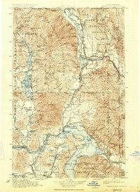
1913 Map of Priest Lake
USGS Topo · Published 1927About this map
Sandpoint sits at the northern end of the vast water system where the Northern Pacific and Great Northern railroads converge. This early twentieth-century survey reveals a landscape of industrial extraction and strategic transport, from the Continental Mine near the Canadian border to the network of logging and passenger lines like the Spokane International. The map documents a period before modern highway dominance, when the Baldwin Ferry provided critical transit and small rail sidings like Elmira and Colburn served as the primary connection points for isolated mountain communities. The vast coverage includes numerous protected lands, including the Kaniksu National Forest and Pend Oreille National Forest, while highlighting geological landmarks such as the iconic Chimney Rock and the high peaks of the Cabinet Mts. Genealogists and local historians can trace the early footprints of settlements like Bonners Ferry, Laclede, and the lakeside community of Cocolalla.
Find a feature on this map
180 named features on this map. Tap any name to fly to it.
Don’t see what you’re looking for? This feature index may not catch every label — zoom into the map to look around manually.
Map Details
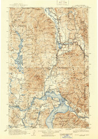
Editions of this 1913 Priest Lake Map
3 editions found
Other maps of this area

1901 · Sandpoint
USGS Topo · 1:125,000

1901 · Spokane
USGS Topo · 1:125,000

1903 · Rathdrum
USGS Topo · 1:125,000

1909 · Cataldo
USGS Topo · 1:125,000

1911 · Cataldo
USGS Topo · 1:125,000

1911 · Priest Lake
USGS Topo · 1:250,000

1911 · Sandpoint
USGS Topo · 1:125,000

1913 · Priest Lake
USGS Topo · 1:250,000

1920 · Libby
USGS Topo · 1:125,000

1930 · Libby
USGS Topo · 1:125,000