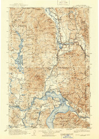
1913 Map of Priest Lake
USGS Topo · Published 1946About this map
The Sandpoint and Bonners Ferry rail corridors dominate this 1913 survey of the Idaho panhandle, illustrating the region's early industrial footprint. Transcontinental transit is evidenced by the Great Northern RR and the Spokane International RR, which connect timber and mining outposts through the Cabinet and Selkirk Mountains. The map documents an era when river crossings were vital, specifically noting the Baldwin Ferry on the Pend Oreille River and the Carey Ferry near the southern border. Mining operations are scattered across the Kaniksu National Forest, with the Continental Mine near the United States Canada Boundary Line and the Mountain Chief Mine further south. Notable for local historians are the numerous siding settlements like Pack River Siding and Summit Siding, which highlight the rail-dependent economy of the early twentieth century.
Find a feature on this map
212 named features on this map. Tap any name to fly to it.
Don’t see what you’re looking for? This feature index may not catch every label — zoom into the map to look around manually.
Map Details
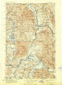
Editions of this 1913 Priest Lake Map
3 editions found
Other maps of this area

1901 · Sandpoint
USGS Topo · 1:125,000

1901 · Spokane
USGS Topo · 1:125,000

1903 · Rathdrum
USGS Topo · 1:125,000

1909 · Cataldo
USGS Topo · 1:125,000

1911 · Cataldo
USGS Topo · 1:125,000

1911 · Priest Lake
USGS Topo · 1:250,000

1911 · Sandpoint
USGS Topo · 1:125,000

1913 · Priest Lake
USGS Topo · 1:250,000

1920 · Libby
USGS Topo · 1:125,000

1930 · Libby
USGS Topo · 1:125,000