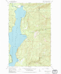
1967 Map of Priest Lake NE
USGS Topo · Published 1982About this map
The northeastern reaches of Priest Lake define this 1967 survey, where the deep waters meet the timbered slopes of the Kaniksu National Forest. The map documents a shoreline transition from the northern The Thorofare and Mosquito Bay down toward the seasonal cabins and recreational sites of the mid-lake. Small-scale infrastructure like the Two Mouth Guard Station and Camp Lodge dot the western edge of the mountains, while the land to the east rises sharply toward Klootch Mtn. Several namesake coves, including Teachers Bay and Distillery Bay, suggest a history of localized use along the lake's edge. A network of jeep trails and pack trails provides the only access into the high drainage basins of Lion Creek and Two Mouth Creek, marking an era before extensive modern road development reached these higher elevations.
Find a feature on this map
47 named features on this map. Tap any name to fly to it.
Don’t see what you’re looking for? This feature index may not catch every label — zoom into the map to look around manually.
Map Details
Editions of this 1967 Priest Lake NE Map
2 editions found
Other maps of this area

1911 · Priest Lake
USGS Topo · 1:250,000

1913 · Priest Lake
USGS Topo · 1:250,000

1958 · Sandpoint
USGS Topo · 1:250,000

1963 · Sandpoint
USGS Topo · 1:250,000

1967 · Priest Lake SE
USGS Topo · 1:24,000

1967 · Priest Lake NE
USGS Topo · 1:24,000

1967 · Priest Lake NW
USGS Topo · 1:24,000

1967 · The Wigwams
USGS Topo · 1:24,000

1967 · Mount Roothaan
USGS Topo · 1:24,000
1967 · Priest Lake SW
USGS Topo · 1:24,000