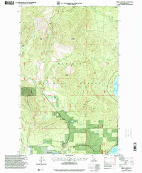
1996 Map of Priest Lake NW
USGS Topo · Published 1999About this map
Kaniksu National Forest defines this northwestern portion of the Idaho panhandle, where the timbered slopes of Granite Mountain and Nickelplate Mountain rise above the western shores of Priest Lake. By the mid-1990s, the small settlement of Nordman served as a key hub for this remote interior, situated near the intersection of Reeder Creek and Granite Creek. The map documents a landscape transitioning from resource extraction to recreation, evidenced by the proximity of the Nickelplate Mine to shoreline developments like Ledgewood and the public docks at Reeder Bay. High-altitude features such as Armstrong Meadows and Beaver Pass reflect the area's difficult topography, while the First Guide Meridian West provides a formal surveying anchor for the intricate network of creeks and forest trails that crisscross the Bismarck Meadows region.
Find a feature on this map
39 named features on this map. Tap any name to fly to it.
Don’t see what you’re looking for? This feature index may not catch every label — zoom into the map to look around manually.
Map Details
Editions of this 1996 Priest Lake NW Map
This is the sole edition of this map. No revisions or reprints were ever made.
Other maps of this area

1911 · Priest Lake
USGS Topo · 1:250,000

1913 · Priest Lake
USGS Topo · 1:250,000

1934 · Metaline
USGS Topo · 1:125,000

1942 · Metaline
USGS Topo · 1:125,000

1958 · Sandpoint
USGS Topo · 1:250,000

1963 · Sandpoint
USGS Topo · 1:250,000

1967 · Priest Lake SE
USGS Topo · 1:24,000

1967 · Priest Lake NE
USGS Topo · 1:24,000

1967 · Priest Lake NW
USGS Topo · 1:24,000

1967 · Helmer Mtn
USGS Topo · 1:24,000