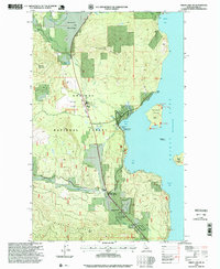
1996 Map of Priest Lake SW
USGS Topo · Published 1999About this map
The western shores of Priest Lake define this landscape within the Kaniksu National Forest, where the transition from high-elevation peaks like Lakeview Mountain to the water's edge is marked by mid-century conservation and recreation efforts. The map reveals a mix of established community infrastructure and forestry management, featuring the 1936 Spruce Plantation and the Hanna Flats Nature Trail. Small clusters of settlement are concentrated at Vans Corner and Lamb Creek, supported by the Priest Lake School and a local Airstrip. The shoreline is active with maritime points of interest, including the Priest Lake Marina and Kalispell Point Boat Ramp, while the lake itself is dotted with prominent landforms such as Kalispell Island and Papoose Island. Historical local activity is further evidenced by several Gravel Pits and the presence of Indian Rock along the coast.
Find a feature on this map
34 named features on this map. Tap any name to fly to it.
Don’t see what you’re looking for? This feature index may not catch every label — zoom into the map to look around manually.
Map Details
Editions of this 1996 Priest Lake SW Map
This is the sole edition of this map. No revisions or reprints were ever made.
Other maps of this area

1901 · Sandpoint
USGS Topo · 1:125,000

1911 · Priest Lake
USGS Topo · 1:250,000

1911 · Sandpoint
USGS Topo · 1:125,000

1913 · Priest Lake
USGS Topo · 1:250,000

1934 · Metaline
USGS Topo · 1:125,000

1936 · Newport
USGS Topo · 1:96,000

1942 · Metaline
USGS Topo · 1:125,000

1942 · Newport
USGS Topo · 1:125,000

1958 · Sandpoint
USGS Topo · 1:250,000

1963 · Sandpoint
USGS Topo · 1:250,000